 The village of North Bradley lies between the towns of Trowbridge and Westbury, and is now separated from the former by only a couple of fields. Until 1866 the parish included the present civil parish of Southwick and, to a great extent, the history of the two villages must be considered together. Until the late 19th century there was no Anglican church at Southwick but the early Baptist movement from the mid 17th century was based on Southwick and a chapel at North Bradley was only built later. Although there would have been village rivalries all villagers would have joined in acts of worship, fairs and social events.
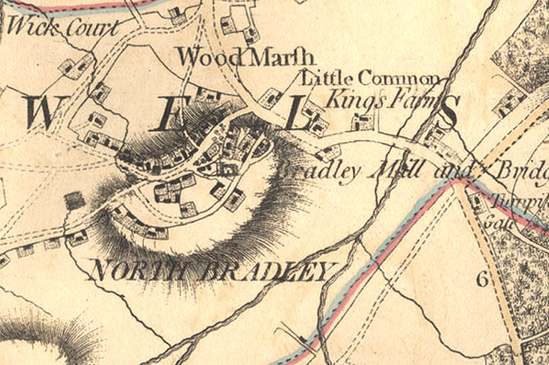
North Bradley is set in the clay vale of the river Biss, which forms part of the parish boundary and several streams run into this river. The highest land lies to the west but all is suitable for arable or pasture. The present parish is long and thin, angled south west to north east, it includes Brokerswood, Cutteridge and Yarnbrook as well as the village itself. The village is now a fairly compact rectangle but the early development was along the Trowbridge to Westbury road and around a U-shaped road, to the west of the main road, that encompasses the church. The parish was once fairly well wooded but today the only substantial wooded area remaining is Brokerswood. Being on clay the houses were often damp and the water supply was poor with the wells often only supplying surface water.
There is little evidence of prehistoric activity here although 2 flint flakes and some flint waste were found on the White Horse Business Park in 1987, while there are undated ring ditches south of the hamlet of Scotland and a linear bank to the south east of the hamlet. There is a little more evidence for the Romano-British period. At Woodmarsh a Romano–British bronze figurine was found in 1988 and a group of 15 coins were separately found there. Sherds of pottery were also found on the White Horse Business Park site in 1987 and a lead coffin and the remains of other burials found south–west of Cutteridge in 1851.
In Saxon times North Bradley was part of the estate of Steeple Ashton, held by Romsey Abbey, and because of this it is included under that estate in the Doomsday Book. We cannot therefore say whether there was a separate village here in Saxon and Norman times, although it is likely that there was some settlement and a mill. The name, meaning a wide clearing, is first mentioned in 1174 but whether it was an agricultural area in woodland (it was part of the forest of Selwood until 1300) or a nucleated settlement is unknown.
There was certainly a settlement here by the 13th century as the church dates from that period. Until the mid 14th century it was treated as a part of Edington, but then it became an independent parish. By the 14th century North Bradley was moderately prosperous. The tax list of 1332 indicates it to be smaller than Edington but larger than Semington. Even at this early stage Southwick was larger than North Bradley, a situation that has remained unchanged ever since.
Brokerswood (1257) and Cutteridge (1241) were first mentioned by name in the 13th century but Yarnbrook (the place beyond the brook) does not appear until 1367. As all are derived from Old English they were probably inhabited form Saxon times. In the 16th century North Bradley grew as a centre of hand loom weaving and squatters’ cottages for clothworkers were erected on the large amounts of common land. Form this time weaving at home was as important as agriculture to the parish. Clothworkers remained numerous until the 19th century but no big clothiers were based here and most weaving was carried out for Trowbridge clothiers. Around 1570 Cutteridge House was built for the Trenchard family. It was very large, said to be second only to Longleat in the county, with a copper covered roof and fine a avenues of trees leading to it. Also in the late 16th century or early 17th century Kings Farm House was built on the Westbury Road and in the 17th century Poles Hole Farm House near Southwick.
By the beginning of the 18th century there was still much common land, in fact the village was surrounded by it. There was Woodmarsh Common to the north, Bradley Common stretching to Southwick, Little Common to the east, and Drynham Common to the north-east, along the Trowbridge boundary. These commons were not enclosed until 1805. Many more houses were built for weavers in the 18th century and the Manor Farm was also rebuilt. At this time Yarbrook was a very small settlement while Scotland and Ireland were squatters’ settlements on common land. There was rivalry between the weavers of Bradley and Southwick leading to jealousy and fights, particularly if one group appeared to be getting more work than the other.
By 1770 there seem to have been 2 fairs held, in May and September. The fair on September 14th was for cattle and cheese, reflecting the predominance of dairying in the local farming economy. The landlord of The Bell, in Church Street organised horse races at both May and September Fairs, while the ground in front of The Bell was well known as bowling green. Around 1790 the rectory was built and the area received literary visitors with such luminaries as the poet and writer Joseph Addison being frequent visitors to Cutteridge House at this period. Unfortunately at this time the cloth workers had only intermittent work and were becoming a heavy burden upon the poor rate, which had to be much increased. This was largely paid by the farmers at a fixed amount per acre farmed. Many workers were given help to pay their house and loom rents, thus keeping them in their own homes. There was no village poor house but over 100 people from both villages were housed in cottages belonging to the parish. In 1831 pauper labourers were allocated to work on farms but they did not work that well and the scheme was unpopular with farmers and was soon abandoned.
Cutteridge Hose was pulled down around 1800 but in the years prior to this visitors were paying one shilling (5p) to look around the house and gardens. Somewhat earlier than Longleat being opened to the public! There were many changes in the early 1800s with the Axe and Cleaver, in Axe and Cleaver Lane, being closed in 1803, when the owner built the Long’s Arms at Yarnbrook instead. The common land was enclosed and land by the Daubeny Almshouses allocated for the fair. Much of the enclosed land was ploughed, the effects of the Napoleon Wars may have necessitated this to produce more grain, and many more houses were built for weavers. Pound Farm was rebuilt on the site of an earlier one that existed by 1600 and in 1810 Charles Daubeny built his Asylum (almshouses) for aged, poor people and a school. In 1818 he opened the Vicar’s poor house for destitute people.
Brewing and licensed premises were also flourishing. Malt houses were built near the church in 1837; the Old Ring of Bells was rebuilt in 1843 and the New Ring of Bells, on the opposite side of the road, was open by 1848. By the middle of the century dairy farming was increasing at the expense of arable while there was suburban housing development along the Trowbridge road, including Beach House and Broadleigh House. In 1855 Sir Roger Brown, factory owner of Trowbridge, built Brokerswood House as a shooting box. In the early 1860s the village acquired another public house when the Rising Sun was opened. At that time there were still 2 fairs although by 1881 there was only one being held in early October and that had become purely a pleasure fair. It survived, in a very small way, until the First World War.
The village of North Bradley and Southwick became separate civil parishes in 1866 and by now they were independent of one another in several ways, although the only Anglican church in Southwick parish was at Rode Hill.
By the 1870s handloom weaving had ceased and large numbers of villagers walked to Trowbridge each day to work in the mills. Gradually the younger ones would find houses in the town and move there permanently. By the 1870s mains water had come to the village and New Inn (now the Marsh Tun) had opened as a beer house. In 1885 the parish boundaries were tidied up and North Bradley covered an area of 1,768 acres.
Village population had been falling from a high point in the 1820s to the 1840s, reaching its lowest point of 809 in 1891 and not rising significantly until after the Second World War. Despite this the village hall (Progressive Hall) was built in 1912. Between the wars small houses were built on the Westbury road but real expansion and development came form the 1970’s onwards. Subsequently housing estates were built to the north of Southwick road and a small one to the south of the church. There has been infilling elsewhere and in 2001 there was a resident population of 1,848.
North Bradley Parish